|
|
|
|
|
|
|
|
|
|
|
|
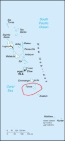
Tanna (island)Vanuatu - Melanesia - Pacific Ocean
It is 40 km (25 mi) long and 19 km (12 mi) wide, with a total area of 550 km² (212 sq mi). Its highest point is the 1,084 m (3,556 ft) summit of Mount Tukosmera. It is the most populated island in Tafea province, with a population of about 20,000, and one of the more populous islands in the country. Isangel, the provincial administrative capital, is on the west coast near the island's largest town of Lénakel. Mount Yasur is the most accessible active volcano in the world, located on the southeast coast. Culture and economy Tanna is populated almost entirely by Melanesians and they follow a more traditional lifestyle than many other islands. Some of the villages are known as kastom villages, where modern inventions are restricted, the inhabitants wear penis sheaths (Bislama: nambas) and grass skirts, and the children do not go to public schools. According to anthropologist Joäl Bonnemaison, who has studied the Tannese extensively, their resistance to change is due to their traditional worldview and how they "perceive, internalise, and account for the dual concepts of space and time." The island is the centre of the Jon Frum cargo cult, which worships an American World War II soldier as their god. Yaohnanen is the centre of the Prince Philip movement, which worships Prince Philip, the Duke of Edinburgh and prince consort of the United Kingdom. There are five languages spoken on Tanna: North Tanna in the northwest, Lénakel in the west-central area near Lénakel, Southwest Tanna in the southwest, Whitesands in the northeast near Whitesands, and Kwamera in the southeast. These are generally grouped into the Tanna languages family, which is a subgroup of the South Vanuatu languages, an Austronesian language branch. According to Ethnologue, each is spoken by a few thousand, and Lénakel, with 6,500 speakers, is one of the languages of Vanuatu with the most speakers. Most people on Tanna also speak Bislama, which is one of Vanuatu's three official languages (together with English and French). The island is one of the most fertile in Vanuatu and produces kava, coffee, coconut, copra, and other fruits and vegetables. Recently, tourism has become more important, as tourists are attracted to the volcano and traditional culture. To help preserve the integrity of culture as a tourism asset, only local people are permitted to act as guides. There are many accommodations available on the island. There is an airport at White Grass on the western coast. History The island was first settled about 400 BC by Melanesians from the surrounding islands. The glowing light of Mount Yasur attracted Captain Cook, the first European, to the island in August 1774, where he founded Port Resolution, a town on the eastern tip of the island, named after his ship HMS Resolution. He gave the island the name of Tanna, probably from the local name for earth, tana in the Kwamera language. In the 19th century, traders and missionaries (chiefly Presbyterian) arrived, but the Tannese stuck to their traditions more strongly than other islands; there remain fewer Christians in comparison with the other islands of Vanuatu. The island became famous in Europe as a place of cannibalism and risk for missionaries. It was not a principal site of World War II, but about 1,000 people from Tanna were recruited to work on the American military base on Éfaté. First exposure to First World living standards may have led to the development of cargo cults. Many have died out, but the John Frum cult remains strong on Tanna today, especially at Sulphur Bay in the south east and Green Point in the South West of the Island. A secessionist movement began in the 1970s, and the Nation of Tanna was proclaimed on March 24, 1974. While the British were more open to allowing its holdings in Vanuatu independence, it was opposed by the French colonists and finally suppressed by the Anglo-French Condominium authorities on June 29, 1974. In 1980, there was another attempt to secede, declaring the Tafea Nation on January 1, 1980, its name coming from the initials of the five islands that were to be part of the nation (Tanna, Aniwa, Futuna, Erromango and Aneityum). British forces intervened on May 26, 1980 allowing the island to become part of the newly independent nation of Vanuatu on July 30, 1980.
All text is available under the terms of the GNU Free Documentation License (see Copyrights for details). About Wikipedia Disclaimers
Mt Yasur Volcano, Tanna Island, Vanuatu
Site Index Back to Top Photos Index Thanks for coming, I hope you
have enjoyed it, will recommend
it to your friends, and will come
back later to see my site developing
and expanding.
|
||||||||||||||||||||||||||||


